Mount Singer
Montagnes-Vertes Nature Reserve. #Hike #Snowshoes #Loop #MontagnesVertes #Nature
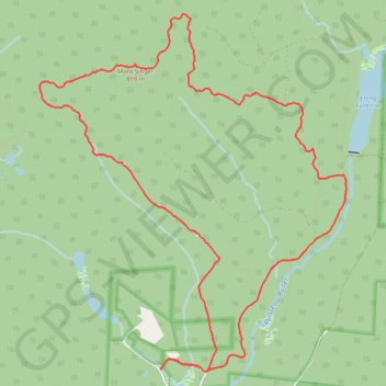
- Distance : 14,2 Km
- Dénivelé positif : 601 m
- Altitude maximum : 800 m
- Dénivelé négatif : 601 m
- Altitude minimum : 284 m
Carte interactive
Profil de la trace GPS
À propos de cette trace GPS
Nom : Trace GPS Mount Singer, itinéraire, parcours
Départ : MontagnesVertes-Decouvertes, Potton, Memphrémagog, Estrie, Quebec, Canada (45.10438 -72.45273)
Arrivée : MontagnesVertes-Decouvertes, Potton, Memphrémagog, Estrie, Quebec, Canada (45.10438 -72.45273)
Coordonnées : 45.10412 -72.46921 45.13825 -72.42766
Autres traces GPS
Cliquez sur une trace GPS pour visualiser son itinéraire, ses statistiques et son profil.