Bromont
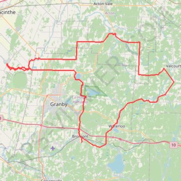
Carte interactive
Profil de la trace GPS
À propos de cette trace GPS
Nom : Trace GPS Bromont, itinéraire, parcours
Départ : Rue Champlain, Bromont, Brome-Missisquoi, Estrie, Québec, J2L 2K7, Canada (45.30246 -72.64051)
Arrivée : Rue Champlain, Bromont, Brome-Missisquoi, Estrie, Québec, J2L 2K7, Canada (45.30249 -72.64052)
Coordonnées : 45.29094 -72.90593 45.57371 -72.31323
Topographie : Carte topographique Brome-Missisquoi
Autres traces GPS
Cliquez sur une trace GPS pour visualiser son itinéraire, ses statistiques et son profil.
Pierreville - Leclercville
Canada > Quebec > Urban agglomeration of Montreal > Montreal
#Bike #Pierreville #Leclercville #Atlantic
Distance : 120,8 Km • Dénivelé positif : 324 m • Altitude maximum : 36 m