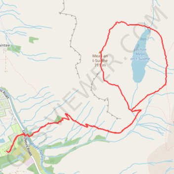
Meall an t-Suidhe and Lochan Meall an t-Suidhe Loop
Loop hike from Glen Nevis to Meall an t-Suidhe and Lochan Meall an t-Suidhe via Ben Nevis Mountain Path. #Hike #Loop #Nature #Forest #Mountain #Lake
- Distance : 9,2 Km
- Dénivelé positif : 757 m
- Altitude maximum : 704 m
- Dénivelé négatif : 757 m
- Altitude minimum : 21 m
- Temps en mouvement : 3 h 50 m
- Vitesse en mouvement : 2,4 Km/h
- Vitesse maximum : 5,3 Km/h
- Temps total : 4 h 46 m
- Vitesse globale : 1,9 Km/h
- Date : 2024-02-11
Carte interactive
Profil de la trace GPS
À propos de cette trace GPS
Nom : Trace GPS Meall an t-Suidhe and Lochan Meall an t-Suidhe Loop, itinéraire, parcours
Coordonnées : 56.79799 -5.07144 56.81376 -5.03595
Autres traces GPS
Cliquez sur une trace GPS pour visualiser son itinéraire, ses statistiques et son profil.
Ben Nevis by the Mountain Path
Royaume-Uni > Écosse > Highland > Glen Nevis > Achintee
GPX file from Walkhighlands; file is copyright Walkhighlands and must not be publicly shared on other websites. Do not remove this notice.
Distance : 16,1 Km • Dénivelé positif : 1 357 m • Altitude maximum : 1 337 m