Multnomah Falls
Carte interactive
Profil de la trace GPS
À propos de cette trace GPS
Nom : Trace GPS Multnomah Falls, itinéraire, parcours
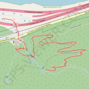
Départ : Columbia River Highway, Multnomah County, Oregon, 97010, United States (45.57882 -122.11845)
Arrivée : Columbia River Highway, Multnomah County, Oregon, 97010, United States (45.57882 -122.11845)
Coordonnées : 45.57580 -122.11845 45.57882 -122.11169
Autres traces GPS
Cliquez sur une trace GPS pour visualiser son itinéraire, ses statistiques et son profil.
Multnomah Falls, Ecola Falls and Wahkeena Falls Loop
United States > Oregon > Multnomah County
Loop hike via Larch Mountain Trail, Benson Bridge, Lower Multnomah Falls, Dutchman Falls, Wiesendanger Falls, Ecola Falls, Wahkeena Trail, Fairy Falls, Lemmons Viewpoint, Wahkeena Falls and Return Trail in the Mount Hood National Forest above the Benson Lake and the Columbia River. #Hike #Loop #Falls #River #Nature #Mountain #Forest…
Distance : 9,2 Km • Dénivelé positif : 1 042 m • Altitude maximum : 506 m
Northern part of the Pacific Crest Trail (PCT)
United States > Oregon > Klamath County
Hike on the Pacific Crest National Scenic Trail from Crater Lake to Canada Border through Oregon and Washington along the Sierra Nevada and Cascade mountain ranges. #Hike #Mountain #SierraNevada #Cascade #Nature #Forest #Park #PCT
Distance : 1 198,3 Km • Dénivelé positif : 44 308 m • Altitude maximum : 2 307 m
Cascade Locks - Sisters
États-Unis d'Amérique > Oregon > Hood River County > Cascade Locks
Vélo. En aller simple entre Cascade Locks et Sisters. #Vélo
Distance : 320,2 Km • Dénivelé positif : 5 945 m • Altitude maximum : 1 470 m