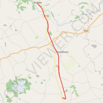
Wilkinstown to Nobber Boyne Valley to Lakelands County Greenway
Lunch Ride
- Distance : 20,3 Km
- Dénivelé positif : 114 m
- Altitude maximum : 85 m
- Dénivelé négatif : 115 m
- Altitude minimum : 52 m
- Temps en mouvement : 1 h 25 m
- Vitesse en mouvement : 14,3 Km/h
- Vitesse maximum : 28,9 Km/h
- Temps total : 1 h 35 m
- Vitesse globale : 12,8 Km/h
- Date : 2024-04-28
Carte interactive
Profil de la trace GPS
À propos de cette trace GPS
Nom : Trace GPS Wilkinstown to Nobber Boyne Valley to Lakelands County Greenway, itinéraire, parcours
Coordonnées : 53.73857 -6.75098 53.82153 -6.70948
Autres traces GPS
Cliquez sur une trace GPS pour visualiser son itinéraire, ses statistiques et son profil.
RT5-1 Rosslare - Kinsale
Distance : 2 860,3 Km • Dénivelé positif : 27 381 m • Altitude maximum : 420 m
RT5-1 Rosslare - Kinsale
Distance : 3 867,1 Km • Dénivelé positif : 36 115 m • Altitude maximum : 524 m