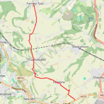
Gate Foot to Farnley Tyas via Thurstonland
Gate Foot - Snowgate Head - Fulstone - Biggin - Top of the Bank - Thurstonland - Top of the Hill - Farnley Tyas
- Distance : 5,8 Km
- Dénivelé positif : 142 m
- Altitude maximum : 288 m
- Dénivelé négatif : 169 m
- Altitude minimum : 202 m
- Temps en mouvement : 1 h 48 m
- Vitesse en mouvement : 3,2 Km/h
- Vitesse maximum : 5,7 Km/h
- Temps total : 2 h 17 m
- Vitesse globale : 2,5 Km/h
- Date : 2024-04-25
Carte interactive
Profil de la trace GPS
À propos de cette trace GPS
Nom : Trace GPS Gate Foot to Farnley Tyas via Thurstonland, itinéraire, parcours
Coordonnées : 53.57459 -1.75583 53.61108 -1.72628
Autres traces GPS
Cliquez sur une trace GPS pour visualiser son itinéraire, ses statistiques et son profil.
Kirklees Way from Gate Foot to Hepworth
United Kingdom > England > Kirklees > Fulstone > Snowgate Head
Snowgate Head - Gate Foot - Jackson Bridge - Hepworth
Distance : 4,7 Km • Dénivelé positif : 137 m • Altitude maximum : 334 m