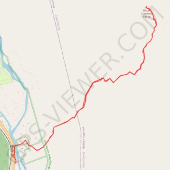
Mount Crawford
Hike from Saco River to Mount Crawford via Davis Path and Mount Crawford Spur in the Presidential Range-Dry River Wilderness. #Hike #Mountain #River #Nature #Forest #Wilderness
- Distance : 7,3 Km
- Dénivelé positif : 629 m
- Altitude maximum : 931 m
- Dénivelé négatif : 627 m
- Altitude minimum : 301 m
- Temps en mouvement : 2 h 12 m
- Vitesse en mouvement : 3,3 Km/h
- Vitesse maximum : 5,8 Km/h
- Temps total : 2 h 37 m
- Vitesse globale : 2,8 Km/h
- Date : 2023-10-04
Carte interactive
Profil de la trace GPS
À propos de cette trace GPS
Nom : Trace GPS Mount Crawford, itinéraire, parcours
Coordonnées : 44.11840 -71.35407 44.13682 -71.33079
Autres traces GPS
Cliquez sur une trace GPS pour visualiser son itinéraire, ses statistiques et son profil.