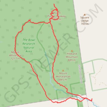
Mount Passaconaway and Mount Whiteface Loop
Loop hike from Ferncroft to Mount Passaconaway via Ferncroft Road, Squirrel Bridge Road, Blueberry Ledge Trail, Rollins Trail, Dicey's Mill Trail, View Spur and Walden Trail in the Sandwich Range Wilderness, the Bowl Research Natural Area and the White Mountain National Forest. #Hike #Loop #Mountain #Forest #Nature #Wilderness
- Distance : 18,8 Km
- Dénivelé positif : 1 262 m
- Altitude maximum : 1 226 m
- Dénivelé négatif : 1 261 m
- Altitude minimum : 353 m
- Temps en mouvement : 5 h 31 m
- Vitesse en mouvement : 3,4 Km/h
- Vitesse maximum : 5,9 Km/h
- Temps total : 6 h 20 m
- Vitesse globale : 3,0 Km/h
- Date : 2023-09-04
Carte interactive
Profil de la trace GPS
À propos de cette trace GPS
Nom : Trace GPS Mount Passaconaway and Mount Whiteface Loop, itinéraire, parcours
Arrivée : 337, Ferncroft, Albany, Carroll County, New Hampshire, 03897, United States (43.91355 -71.35804)
Coordonnées : 43.91157 -71.40782 43.95755 -71.35800
Autres traces GPS
Cliquez sur une trace GPS pour visualiser son itinéraire, ses statistiques et son profil.