The Storr - ascent
GPX file from Walkhighlands; file is copyright Walkhighlands and must not be publicly shared on other websites. Do not remove this notice.
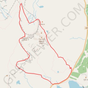
- Distance : 7,9 Km
- Dénivelé positif : 569 m
- Altitude maximum : 708 m
- Dénivelé négatif : 569 m
- Altitude minimum : 153 m
Carte interactive
Profil de la trace GPS
À propos de cette trace GPS
Nom : Trace GPS The Storr - ascent, itinéraire, parcours
Départ : A855, Highland, Écosse, IV51 9HX, Royaume-Uni (57.49769 -6.15936)
Arrivée : A855, Highland, Écosse, IV51 9HX, Royaume-Uni (57.49771 -6.15937)
Coordonnées : 57.49393 -6.18765 57.51635 -6.15910
Autres traces GPS
Cliquez sur une trace GPS pour visualiser son itinéraire, ses statistiques et son profil.
Skye Trail
Royaume-Uni > Écosse > Highland > Shulista
Distance : 127,4 Km • Dénivelé positif : 3 959 m • Altitude maximum : 655 m
The Old Man of Storr
Royaume-Uni > Écosse > Highland
GPX file from Walkhighlands; file is copyright Walkhighlands and must not be publicly shared on other websites. Do not remove this notice.
Distance : 5,1 Km • Dénivelé positif : 335 m • Altitude maximum : 493 m
Hebrideanway
Royaume-Uni > Écosse > Na h-Eileanan Siar > Baile Bhatarsaigh
Distance : 322,3 Km • Dénivelé positif : 4 198 m • Altitude maximum : 268 m