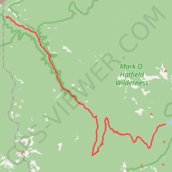
Eagle Creek and Falls
Hike from Columbia River to the Wahtum Lake along Eagle Creek via Metlako Falls, Sorenson Falls, Punch Bowl Falls, Four Mile Falls, Wy east Falls, Grand Union Falls, Tunnel Falls and Twister Falls in the Mark O. Hatfield Wilderness. #Hike #River #Falls #Canyon #Forest #Mountain #Lake #Wilderness
- Distance : 21,1 Km
- Dénivelé positif : 1 778 m
- Altitude maximum : 1 144 m
- Dénivelé négatif : 681 m
- Altitude minimum : 42 m
Carte interactive
Profil de la trace GPS
À propos de cette trace GPS
Nom : Trace GPS Eagle Creek and Falls, itinéraire, parcours
Arrivée : Chindere Cutoff Trail #406M, Hood River County, Oregon, United States (45.58111 -121.80109)
Coordonnées : 45.56448 -121.91966 45.63727 -121.80097
Autres traces GPS
Cliquez sur une trace GPS pour visualiser son itinéraire, ses statistiques et son profil.
Northern part of the Pacific Crest Trail (PCT)
United States > Oregon > Klamath County
Hike on the Pacific Crest National Scenic Trail from Crater Lake to Canada Border through Oregon and Washington along the Sierra Nevada and Cascade mountain ranges. #Hike #Mountain #SierraNevada #Cascade #Nature #Forest #Park #PCT
Distance : 1 198,3 Km • Dénivelé positif : 44 308 m • Altitude maximum : 2 307 m
Cascade Locks - Sisters
États-Unis d'Amérique > Oregon > Hood River County > Cascade Locks
Vélo. En aller simple entre Cascade Locks et Sisters. #Vélo
Distance : 320,2 Km • Dénivelé positif : 5 945 m • Altitude maximum : 1 470 m