Dog Falls and Coire Loch, Glen Affric
GPX file from Walkhighlands; file is copyright Walkhighlands and must not be publicly shared on other websites. Do not remove this notice.
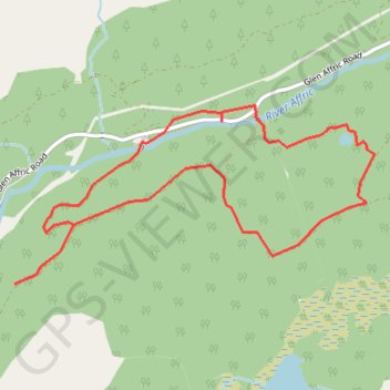
- Distance : 6,1 Km
- Dénivelé positif : 220 m
- Altitude maximum : 306 m
- Dénivelé négatif : 220 m
- Altitude minimum : 177 m
Carte interactive
Profil de la trace GPS
À propos de cette trace GPS
Nom : Trace GPS Dog Falls and Coire Loch, Glen Affric, itinéraire, parcours
Départ : Dog Falls carpark, Glen Affric Road, Highland, Écosse, IV4 7LY, Royaume-Uni (57.31243 -4.85223)
Arrivée : Dog Falls carpark, Glen Affric Road, Highland, Écosse, IV4 7LY, Royaume-Uni (57.31242 -4.85222)
Coordonnées : 57.30554 -4.86371 57.31420 -4.83128