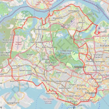
Directions from Duck Tour Ramp to Marina Boulevard, Singapore
- Distance : 105,3 Km
- Dénivelé positif : 812 m
- Altitude maximum : 51 m
- Dénivelé négatif : 812 m
- Altitude minimum : -4 m
Carte interactive
Profil de la trace GPS
À propos de cette trace GPS
Nom : Trace GPS Directions from Duck Tour Ramp to Marina Boulevard, Singapore, itinéraire, parcours
Départ : Marina Promenade, Tanjong Rhu, Kallang, Singapore, Central, 437440, Singapore (1.29657 103.86389)
Arrivée : Marina Promenade, Tanjong Rhu, Kallang, Singapore, Central, 437440, Singapore (1.29657 103.86389)
Coordonnées : 1.26559 103.68782 1.46409 103.87231
Autres traces GPS
Cliquez sur une trace GPS pour visualiser son itinéraire, ses statistiques et son profil.
Bukit Timah Hill - MacRitchie Reservoir
Singapore > Southwest > Singapore
#Hike
Distance : 14,8 Km • Dénivelé positif : 290 m • Altitude maximum : 167 m
The Green Corridor - Singapore
Singapore > Northwest > Singapore
#Hike
Distance : 22,3 Km • Dénivelé positif : 167 m • Altitude maximum : 44 m
Singapore Botanical Gardens
Distance : 10,6 Km • Dénivelé positif : 161 m • Altitude maximum : 40 m
Singapore East Coast Park
Singapore > Southeast > Singapore
#Hike
Distance : 12,6 Km • Dénivelé positif : 79 m • Altitude maximum : 22 m
Sungei Buloh Wetland Route
Singapore > Southwest > Singapore
Enjoy the tranquility and serenity of the mangrove habitat is through Route 1. This route goes around the two main ponds and gives a good introduction to the Reserve and the birds of Sungei Buloh, especially during the migratory season from September to March From https://www.aussiebushwalking.com/overseas/sungei-buloh-wetland-route-1
Distance : 2,6 Km • Dénivelé positif : 16 m • Altitude maximum : 9 m
Singapore Botanical Gardens.gpx
Singapore > Central > Singapore
Distance : 10,6 Km • Dénivelé positif : 161 m • Altitude maximum : 40 m
Kualanamu International Airport to Jakarta, Indonesia
Indonésie > Sumatra du Nord > Deli Serdang > Beringin
Distance : 1 809,2 Km • Dénivelé positif : 10 977 m • Altitude maximum : 125 m
Singapore Botanical Gardens
Singapore > Central > Singapore
Distance : 10,6 Km • Dénivelé positif : 161 m • Altitude maximum : 40 m
Labrador Park
Singapore > Central > Singapore
#Hike
Distance : 8,0 Km • Dénivelé positif : 91 m • Altitude maximum : 27 m