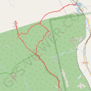
Mount Field, Mount Willey, Mount Avalon and Mount Tom Loop
Loop hike from Sako Lake via Avalon Trail, Mount Avalon, Mount Field, Willey Range Trail, Mount Willey, Mount Tom Spur, Mount Tom and A-Z Trail in the White Mountain National Forest. #Hike #Loop #Mountain #Nature #Forest #Lake
- Distance : 15,2 Km
- Dénivelé positif : 1 021 m
- Altitude maximum : 1 299 m
- Dénivelé négatif : 1 021 m
- Altitude minimum : 575 m
- Temps en mouvement : 4 h 41 m
- Vitesse en mouvement : 3,2 Km/h
- Vitesse maximum : 5,1 Km/h
- Temps total : 5 h 33 m
- Vitesse globale : 2,7 Km/h
- Date : 2023-08-23
Carte interactive
Profil de la trace GPS
À propos de cette trace GPS
Nom : Trace GPS Mount Field, Mount Willey, Mount Avalon and Mount Tom Loop, itinéraire, parcours
Départ : Crawford, Avalon Trail, Carroll, Coös County, New Hampshire, United States (44.21778 -71.41122)
Arrivée : Crawford, Avalon Trail, Carroll, Coös County, New Hampshire, United States (44.21771 -71.41122)
Coordonnées : 44.18331 -71.44647 44.21778 -71.41122
Autres traces GPS
Cliquez sur une trace GPS pour visualiser son itinéraire, ses statistiques et son profil.