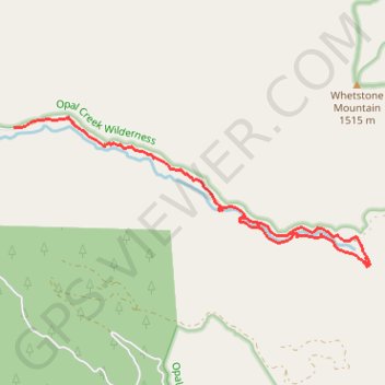
Opal Creek
Loop hike to the Opal Creek along Little North Santiam River via Sawmill Falls, Opal Pool and Kopetski Trail in the Opal Creek Wilderness. #Hike #Loop #Nature #River #Forest #Falls #Mountain #Wilderness
- Distance : 9,3 Km
- Dénivelé positif : 451 m
- Altitude maximum : 671 m
- Dénivelé négatif : 442 m
- Altitude minimum : 567 m
- Temps en mouvement : 2 h 57 m
- Vitesse en mouvement : 3,1 Km/h
- Vitesse maximum : 5,5 Km/h
- Temps total : 5 h 10 m
- Vitesse globale : 1,8 Km/h
- Date : 2018-07-03
Carte interactive
Profil de la trace GPS
À propos de cette trace GPS
Nom : Trace GPS Opal Creek, itinéraire, parcours
Départ : National Forest Development Road 2209, Marion County, Oregon, United States (44.85988 -122.26435)
Arrivée : Kopetski Trail, Marion County, Oregon, United States (44.84940 -122.22636)
Coordonnées : 44.84364 -122.26435 44.86105 -122.20565