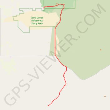
Bend to Alvord Section 2 - Christmas Valley to A6 Intruder Route
- Distance : 39,6 Km
- Dénivelé positif : 244 m
- Altitude maximum : 1 430 m
- Dénivelé négatif : 125 m
- Altitude minimum : 1 311 m
Carte interactive
Profil de la trace GPS
À propos de cette trace GPS
Nom : Trace GPS Bend to Alvord Section 2 - Christmas Valley to A6 Intruder Route, itinéraire, parcours
Départ : Lake County, Oregon, 97736, United States (43.35580 -120.37527)
Arrivée : Lake County, Oregon, United States (43.11250 -120.36093)
Coordonnées : 43.11250 -120.37527 43.36576 -120.29614
Autres traces GPS
Cliquez sur une trace GPS pour visualiser son itinéraire, ses statistiques et son profil.
Bend to Alvord Section 1 - Bend to Christmas Valley Sand Dunes
United States > Oregon > Deschutes County > Bend
Distance : 158,7 Km • Dénivelé positif : 887 m • Altitude maximum : 1 559 m