Linville Falls
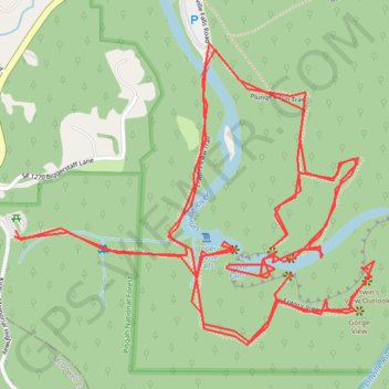
Hike from Linville Gorge Parking to Linville Falls via Erwin's View Trail, Upper Falls Overlook, Chimney View, Gorge View, Erwin's View Outlook, Linville Falls Trail, Linville River, Plunge Basin Trail, Plunge Basin Overlook and Plunge Basin in the Blue Ridge Parkway and the Pisgah National Forest. #Hike #River #Falls #Nature #Mountain #Forest #Appalachian
- Distance : 7,8 Km
- Dénivelé positif : 413 m
- Altitude maximum : 1 019 m
- Dénivelé négatif : 414 m
- Altitude minimum : 938 m
- Temps en mouvement : 2 h 4 m
- Vitesse en mouvement : 3,8 Km/h
- Vitesse maximum : 11,7 Km/h
- Temps total : 4 h 37 m
- Vitesse globale : 1,7 Km/h
- Date : 2016-09-03
Carte interactive
Profil de la trace GPS
À propos de cette trace GPS
Nom : Trace GPS Linville Falls, itinéraire, parcours
Départ : Kistler Memorial Highway, Burke County, North Carolina, 28647, United States (35.95019 -81.93343)
Arrivée : Kistler Memorial Highway, Burke County, North Carolina, 28647, United States (35.95034 -81.93340)
Coordonnées : 35.94761 -81.93343 35.95478 -81.92286
Autres traces GPS
Cliquez sur une trace GPS pour visualiser son itinéraire, ses statistiques et son profil.
08.10.2017
United States > North Carolina > Haywood County
File with points/tracks from Locus Map Classic/3.70.9
Distance : 462,9 Km • Dénivelé positif : 8 858 m • Altitude maximum : 2 019 m