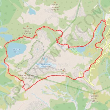
Chain Lakes and Wild Goose Trails Loop
Loop hike via Bagley Dam, Chain Lakes Trail, Bagley Lakes, Iceberg Lake, Mazama Lake, Wild Goose Trail, Terminal Lake and Heather Meadows in the Mount Baker Wilderness. #Hike #Loop #Lake #Nature #Mountain #River #Forest #Wilderness
- Distance : 12,5 Km
- Dénivelé positif : 623 m
- Altitude maximum : 1 666 m
- Dénivelé négatif : 622 m
- Altitude minimum : 1 284 m
- Temps en mouvement : 4 h 22 m
- Vitesse en mouvement : 2,8 Km/h
- Vitesse maximum : 5,9 Km/h
- Temps total : 7 h 16 m
- Vitesse globale : 1,7 Km/h
- Date : 1998-08-20
Carte interactive
Profil de la trace GPS
À propos de cette trace GPS
Nom : Trace GPS Chain Lakes and Wild Goose Trails Loop, itinéraire, parcours
Coordonnées : 48.84334 -121.72240 48.86180 -121.68229
Autres traces GPS
Cliquez sur une trace GPS pour visualiser son itinéraire, ses statistiques et son profil.
Northern part of the Pacific Crest Trail (PCT)
United States > Oregon > Klamath County
Hike on the Pacific Crest National Scenic Trail from Crater Lake to Canada Border through Oregon and Washington along the Sierra Nevada and Cascade mountain ranges. #Hike #Mountain #SierraNevada #Cascade #Nature #Forest #Park #PCT
Distance : 1 198,3 Km • Dénivelé positif : 44 308 m • Altitude maximum : 2 307 m