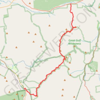
Presidential Range Traverse
Hike via Mount Madison, Mount Adams, Mount Jefferson, Mount Washington, Mount Monroe, Mount Franklin, Mount Eisenhower, Mount Pierce and Mount Jackson in the White Mountain National Forest. #Hike #Mountain #Forest #Nature #Lake
- Distance : 32,3 Km
- Dénivelé positif : 2 545 m
- Altitude maximum : 1 911 m
- Dénivelé négatif : 2 369 m
- Altitude minimum : 399 m
- Temps en mouvement : 13 h 44 m
- Vitesse en mouvement : 2,4 Km/h
- Vitesse maximum : 9,9 Km/h
- Temps total : 16 h 7 m
- Vitesse globale : 2,0 Km/h
- Date : 2022-08-20
Carte interactive
Profil de la trace GPS
À propos de cette trace GPS
Nom : Trace GPS Presidential Range Traverse, itinéraire, parcours
Arrivée : Webster-Jackson Trail, Carroll, Coös County, New Hampshire, United States (44.21514 -71.40792)
Coordonnées : 44.20248 -71.40792 44.37145 -71.27652
Autres traces GPS
Cliquez sur une trace GPS pour visualiser son itinéraire, ses statistiques et son profil.
Mount Washington, Lion Head and Tuckerman Ravine Loop
United States > New Hampshire > Coos County
Loop hike from Pinkham Notch to Mount Washington via Tuckerman Ravine Trail, Crystal Cascades Falls and Lion Head Trail in the Pinkham Notch Scenic Area, the Mount Washington State Park and the White Mountain National Forest. #Hike #Loop #Mountain #Nature #Forest #Falls #Park
Distance : 12,6 Km • Dénivelé positif : 1 325 m • Altitude maximum : 1 911 m
Mount Adams and Mount Madison Loop
United States > New Hampshire > Coos County > Randolph
Loop hike from Appalachia Trailhead to Mount Adams and Mount Madison via Airline Trail, Gulfside Trail, Madison Spring Hut, Osgood Trail, Watson Path and Valley Way in the Whites Mountains National Forest. #Hike #Loop #Mountain #Nature #Forest
Distance : 13,8 Km • Dénivelé positif : 1 511 m • Altitude maximum : 1 754 m
Mount Isolation, North Isolation and Gulf Peak
United States > New Hampshire > Coos County
Hike to Mount Isolation via Glen Boulder Trail, Gulf Peak, Davis Path, North Isolation and Isolation Trail in the White Mountain National Forest, the Pinkham North Scenic Area and the Presidential Range-Dry River Wilderness. #Hike #Mountain #Nature #Forest #Wilderness
Distance : 17,4 Km • Dénivelé positif : 1 411 m • Altitude maximum : 1 572 m
Mount Jefferson
United States > New Hampshire > Coos County
Hike from Madison Spring Hut to Mount Jefferson via Star Lake, Mount Adams, Israel Ridge, Gulfside Trail and Mount Jefferson Trail in the Great Gulf Wilderness and the White Mountain National Forest. #Hike #Mountain #Nature #Forest #Wilderness
Distance : 5,0 Km • Dénivelé positif : 522 m • Altitude maximum : 1 754 m