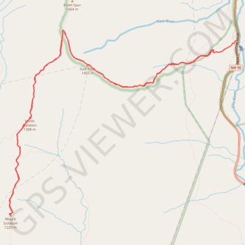
Mount Isolation, North Isolation and Gulf Peak
Hike to Mount Isolation via Glen Boulder Trail, Gulf Peak, Davis Path, North Isolation and Isolation Trail in the White Mountain National Forest, the Pinkham North Scenic Area and the Presidential Range-Dry River Wilderness. #Hike #Mountain #Nature #Forest #Wilderness
- Distance : 17,4 Km
- Dénivelé positif : 1 411 m
- Altitude maximum : 1 572 m
- Dénivelé négatif : 1 510 m
- Altitude minimum : 599 m
- Temps en mouvement : 6 h 22 m
- Vitesse en mouvement : 2,7 Km/h
- Vitesse maximum : 5,3 Km/h
- Temps total : 7 h 19 m
- Vitesse globale : 2,4 Km/h
- Date : 2023-08-21
Carte interactive
Profil de la trace GPS
À propos de cette trace GPS
Nom : Trace GPS Mount Isolation, North Isolation and Gulf Peak, itinéraire, parcours
Départ : Glen Boulder Trail, Pinkham's Grant, Coös County, New Hampshire, United States (44.24400 -71.25946)
Coordonnées : 44.21485 -71.30951 44.24748 -71.25369
Autres traces GPS
Cliquez sur une trace GPS pour visualiser son itinéraire, ses statistiques et son profil.
Presidential Range Traverse
United States > New Hampshire > Coos County > Bowman
Hike via Mount Madison, Mount Adams, Mount Jefferson, Mount Washington, Mount Monroe, Mount Franklin, Mount Eisenhower, Mount Pierce and Mount Jackson in the White Mountain National Forest. #Hike #Mountain #Forest #Nature #Lake
Distance : 32,3 Km • Dénivelé positif : 2 545 m • Altitude maximum : 1 911 m